Oahspe Study:
Geological Evidence of Submerged Continent in the Pacific
Ancient Sea Levels drop:
· The Mississippi and Amazon Basins of America are drained
· Marine Fossils of similar and associated species found around the globe including the deserts of Africa and Australia
Major Ocean Currents change:
· Global Climactic Changes and significant extinction of animal and plant species
Submergence of the Great Continent also causes:
· Rift Valleys and the Uplift of Lands
· The Pacific Ring of Fire (volcanic activity)
· Myriads of Pacific Islands which were once the Mountaintops of Pan
......These are just some of the changes to the geophysical condition of the earth when the continent of Pan was submerged in what became the Pacific Ocean.
|
|
|
|
|
|
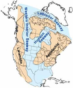
Pan is shown in the Oahspe
Pre-Flood Map of the World around 25,000 |
Sea-Levels shown on Oahspe’s
Post-Flood Map of the World with names |
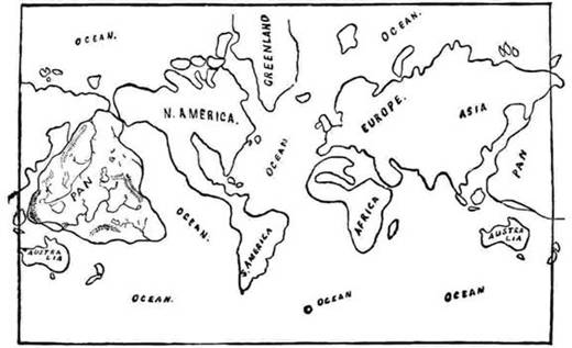
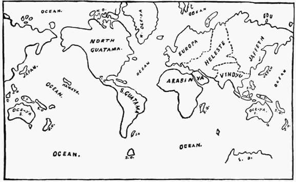
When the huge land mass of the continent of Pan was forced to the bottom of the ocean it caused a change to the face of the globe not only by the creation of the largest ocean on the planet, but the displacement of water caused the sea levels around the globe to fall drastically. It seems, also that the uplifting of lands in response to the gigantic pressure against the crust and mantle of the planet was also a contributory cause to a shift in sea-levels in many areas. In this regard, consider the analogy of a balloon, if great inward pressure was exerted on one side, the balloon would expand elsewhere. Such tremendous downward, inward pressures that came to bear upon the crust of the earth (which was the continent of Pan) affected far distant regions around the globe. This "ballooning" pressure would have created and exacerbated thin and broken areas of earth's crust. Such stresses would have resulted in rifts and uplifts in both land and undersea areas. Consequent changes to the face of the globe can be seen in the differences in the shape of landmasses when comparing the Pre-Flood and Post-Flood Maps in Oahspe (the post flood map is close to present day appearance of the globe). Although both maps are roughly scaled hand drawn sketches, there is clear evidence of at least four distinct areas where the land (now part of the continents of Africa, Australia, North America and South America) was under water prior to the Flood (the sinking of the great continent of Pan).
|
|
|
|
|
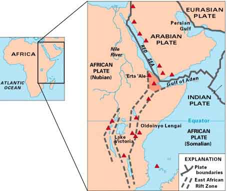
Showing the East African Rift - which continues North through Israel and Jordan as far as Syria
|
|
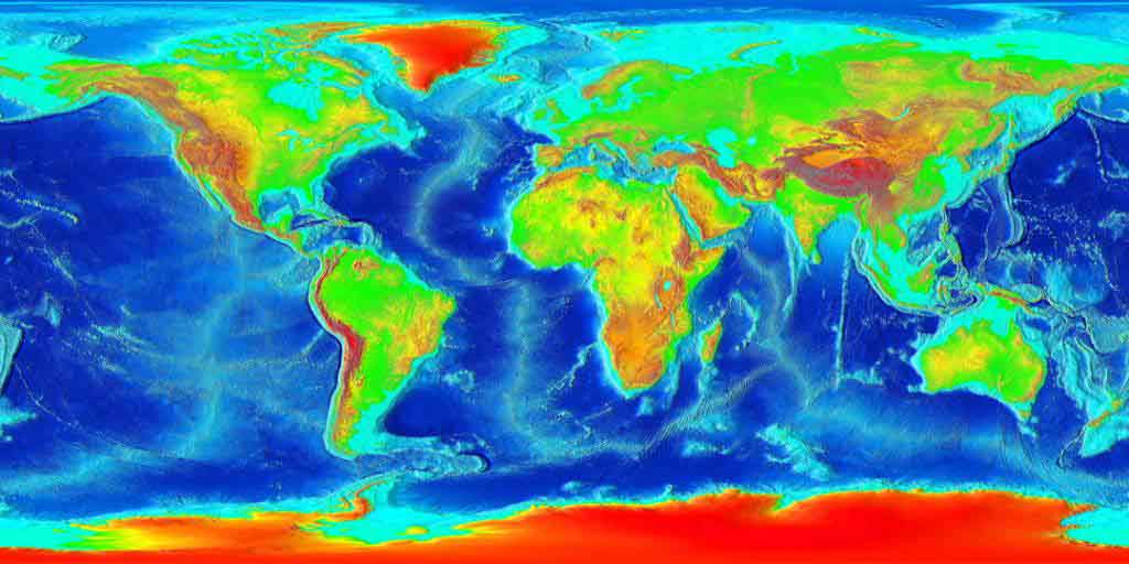
Comparing a modern day bathymetric map with Oahspe’s Pre Flood Map, the once undersea areas are now lowland areas above sea level.
|
Areas of note are:
· Northern Africa and the Mediterranean - Egypt and a large portion of the Sahara stretching west all the way to Mauritania and Mali (where there are many marine fossils) as well as coastal areas around the continent of Africa; The Great Rift Valley that runs from Syria down to Mozambique; Areas around the Dead Sea, the Caspian Sea and the Mediterranean Coast.
· Australia - The Great Sandy Desert, Canning Basin and Kimberly regions in North Western Australia; Arnhem Land and Kakadu in Northern Territory; the South West and Great Southern Regions of Western Australia.
· North America - From Texas to Mississippi and Louisiana Basin, and the East Coast.
· South America - large section of the lowlands of the Amazon Shield and the Eastern side of the continent exposing what is now Brazil and Argentina including the Falkland Islands; On the West Coast, an arc of the coastline of Peru.
· Europe - the British Isles as separated from each other and from the greater landmass of Europe. The Netherlands and parts of Scandinavia and Germany also appear underwater (the post-flood map shows Great Britain as connected to Europe and the lowlands of Netherlands and Germany being above land.
[This European minor variation of the post-flood map to modern day maps may be an indicator that the post-flood map belongs to an earlier period when sea levels were somewhat lower than at present (around 9,000 years ago), in the time of Fragapatti.]
All the above mentioned areas yield fossil evidence of being under the sea in relatively recent geological history. Various marine fossils such as extinct sharks and sea mammals which favored warm shallow waters (including Basilosaurus and Squaladon extinct whales) of the late Eocene and early Oligocene periods have been found in Africa, North America and Australia. Such fossils being found far from any coast, and in great numbers and good condition (whole skeletons and even stomach contents have been preserved in some cases) supports evidence in the geological record of a sudden cataclysmic drop in global sea levels when some species of marine fish and (sea) mammals became extinct.
The climate change of the late Eocene and Oligocene periods was most likely due to great changes in ocean currents following the loss of a great tropical global land mass such as the Continent of Pan which occurred 25,000 years ago. Such significant redistribution of land and sea caused by the submergence of this great land mass led to a general cooling, particularly in areas more distant from the Equator. Scientists have attempted to explain such events in the geological record of these significant sea, land and climate changes with "Tectonics and Continental Drift Theories". But these hypotheses speculate that continents gradually float around the globe during ludicrously long periods of time, unnecessarily classifying geological periods as millions of years long and tens of millions of years in the past. Similar to the fictions of Evolution theory, such hypothesis depend upon the supposition that unexplained changes occur over tens and hundreds of millions of years. Attributing great time periods to unexplained phenomenon seems to be a popular device among scientists to conjure credibility to such "self-made", "by chance" modalities of causation that deny the existence of an omnipotent Creator. Notwithstanding the ridiculously extended ages allocated by conventional scientists, the fact remains that a number of geological events converged around particular adjacent periods, supporting the fact that one significant event set the conditions for the otherwise inexplicable associated geological changes. It is with this caveat (that unrealistic periods of time estimated by conventional science, as well as unsubstantiated hypotheses of causes have been included) that the following relevant information of the Earth's Geologic Record is presented:
Draining of Mississippi and Amazon Basins of America
A great part of the Amazon Basin was once a gulf of the Atlantic Ocean:
|| The lower Amazon seems to have once been a gulf of the Atlantic Ocean, the water of which washed the cliffs near Obidos.....From the village of Canaria at the great bend of the Amazon to the Negro 1,000 km (600 mi) downstream, only very low land is found, resembling that at the mouth of the river. Vast areas of land in this region are submerged at high water, above which only the upper part of the trees of the sombre forests appear. Near the mouth of the Rio Negro to Serpa, nearly opposite the river Madeira, the banks of the Amazon are low, until approaching Manaus, they rise to become rolling hills..... ||
Whale Fossils in the Mississippi Basin and Australia:
|| The bones of Basilosaurus cetoides (Owen) and other primitive whales have been found throughout a belt across Louisiana, Mississippi and Alabama where exposures to Middle and Upper Eocene marine strata, called the Moodys Branch Formation (or Marl) and the Yazoo Clay occur. The vertebrates were so common within some areas of this belt that local residents used them as andirons for fireplaces and blocks to support cabins. The bones and skeletons of Basilosaurus also have been found in Australia, Egypt and other marine sediments of Upper Eocine Age Domning 1969, Johnston 1991, Thurmond 1981). || retrieved 1 Sept, 05.
|
|
|
|
|
Marine Fossils from Texas, Arkansas, Florida indicate that a large area of the Southern United States, stretching up the centre of the continent was underwater in the near ancient past.
|
Ancient Sea-Levels and Temperatures Drop
When Sea Levels and Temperatures Dropped around the Globe:
The Oligocene is a geologic epoch of the Paleogene period and extends from about 33.9 million to 23 million years before the present. As with other older geologic periods, the rock beds that define the period are well identified but the exact dates of the start and end of the period are slightly [!!] uncertain. The name Oligocene ..... refers to the sparsity of additional modern mammalian species of fauna after a burst of evolution during the Eocene. The Oligocene is preceded by the Eocene epoch and is followed by the Miocene epoch. The Oligocene is the third and final epoch of the Paleogene period.
The Oligocene is often considered an important time of transition, a link between the archaic world of the tropical Eocene and the more modern ecosystems of the Miocene. Major changes during the Oligocene included a global expansion of grasslands, and a regression of tropical broad leaf forests to the equatorial belt.
The start of the Oligocene is marked by a notable extinction event called the Grande Coupure; it featured the replacement of European fauna with Asian fauna, except for the endemic rodent and marsupial families. By contrast, the Oligocene-Miocene boundary is not set at an easily identified worldwide event but rather at regional boundaries between the warmer late Oligocene and the relatively cooler Miocene.
The Paleogene period general temperature decline is interrupted by an Oligocene 7 million year stepwise climate change. A deeper 8.2 deg.C, 400,000 year temperature depression leads the 2 deg.C, 7 million year stepwise climate change 33.5 Ma (Million years ago). The stepwise climate change began 32.5Ma and lasted through to 25.5Ma, as depicted in the PaleoTemps chart. The Oligocene climate change was a global increase in ice volume and a 55 m (181 feet) decrease in sea level (35.7-33.5 Ma) with a closely related (25.5-32.5 Ma) temperature depression. The 7 million year depression abruptly terminated within 1-2 million years of the La Garita Caldera eruption at 28-26 Ma. A deep 400,000 year glaciated Oligocene Miocene boundary event is recorded at McMurdo Sound and King George Island [Antarctica].
[ || ...as large as possible volcanic eruptions may be, even they need help from one to many somethings equally or more powerful to push this planet over the edge into massive climate change or mass extinctions.... || What Happened at the End of the Eocene]
.....A brief marine incursion marks the early Oligocene in Europe. Marine fossils from the Oligocene are rare in North America. There appears to have been a land bridge in the early Oligocene between North America and Europe, since the faunas of the two regions are very similar.
[Note that high sea-levels of that same period would cover any land bridge, however, the land connection between the Asia and North America existed in the form of Pan. See the position of the Northern Tip of Pan in the Pre-Flood map of the world.].....The Oligocene sees the beginnings of modern ocean circulation, with tectonic shifts causing the opening and closing of ocean gateways. Cooling of the oceans had already commenced by the Eocene/Oligocene boundary and they continued to cool as the Oligocene progressed. The formation of permanent Antarctic ice sheets during the early Oligocene and possible glacial activity in the Arctic may have influenced this oceanic cooling, though the extent of this influence is still a matter of some significant dispute.
Fossil Evidence of a change in Global Sea Levels :
[During] the Late Eocene Epoch
(37.2 through 33.9 million years ago) the global climates remained much warmer
than today and sea levels were much higher. The poles were likely ice free.....
low stands of sea levels were at least ten meters (32+ feet) higher than today's
average sea levels.
At 33.9 million years ago a series of dramatic, sudden episodes of global
cooling triggered repeated glaciation and repetitive retreats of sea levels. In
the first one coast lines fell globally perhaps 15 meters (49+ feet) below
current levels. This opened the Oligocene Epoch, being warm water whales the
basilosaurids did not survive this cooling period [in areas further distant
from equatorial sea-currents].....
The Squalodon [whale] family of the Oligocene [with teeth and echolocation have been found in] Florida and South Carolina.....They have additionally been reported from the United States' East, West and Gulf Coasts, Argentina, Australia, Austria, Chile, Costa Rica, Belgium, England, France, Germany, Greece, Hungary, Italy, Malta, Mexico, The Netherlands, Sicily, Switzerland, and Venezuela.
Africa's Shallow Seas
|| .....The African Surface was episodically flooded, and the major Oligocene regression, which coincides with the establishment of the Antarctic ice sheet as well as the beginning of the rise of Africa's swells, is revealed in much of Africa's offshore sedimentary and onshore geomorphic record... .. || The African Erosion Surface: A Continental-scale Synthesis of Geomorphology by Kevin Burke and Yanni Gunnell pp 14
Ancient Whale Fossils in Peru
|| Sep 12, 2011: ....we focused our efforts on older rocks of the Paracas Formation [Peru], which have recently yielded remarkable giant penguins of Eocene age....Our team discovered three different kinds of archaeocetes from strata several dozens of meters below a volcanic ash bed....the fossils were discovered in the Ica desert..... we knew that the fossil whales we discovered were no younger than 36.61 million years old.....we discovered that the three specimens represented two different types of archaeocetes [ancient whales].... One was a protocetid. This group of archaeocetes possessed four, full limbs, suggesting a semi-aquatic lifestyle. The other two specimens belonged to basilosaurids..... ||
Marine Fossils in the deserts of North West Africa, Egypt and Australia
Whale Fossils found in Western Sahara:
|| .....Massive [6 inch] associated pair of Basilosaurus Whale Canines from Dakhla Morocco. These are associated with teeth found together on the coastal cliffs of the Western Sahara..... ||
|| Cairo, Egypt: University of Michigan paleontologist Philip D Gingerich and colleagues at the EGYPTIAN environmental Affairs Agency (EEAA) announced April 10 [2005] the successful excavation of an unusually complete and well-preserved skeleton of the 40 million-year-old fossil whale - Basilosaurus isis......Sea-living animals found in the Wadi Hitan (100 kilometers southwest of Cairo) desert include five species of whales, including the Dorudon atrox, presently exhibited in the University of Michigan Exhibit Museum. There are also three species of sea cows (Sirenia), two crocodiles, several turtles, and a sea snake, in addition to a large number of fossilized sharks and bony fishes. || retrieved 1 Sept 05.
Many ancient marine reptiles and mammal fossils found in Egyptian Desert:
|| Although the fossils at Wadi al-Hitan (The Whale Valley) are certainly not the oldest in the world, their sheer number and remarkable preservation (even some stomach contents are still intact!) make them invaluable to paleontologists and evolutionary scientists. .....the diversity of fossils seen at Wadi al-Hitan. Aside from the impressive archaeocete fossils, the largest of which measures 21 meters in length, fossils of other early animals such as sharks, crocodiles, and turtles are also found at the site. ||
(Note that these fossils were not found until the 20th century (1902) and therefore the information in Oahspe regarding the under
sea areas was neither common knowledge nor able to be confirmed until more recent times).
Sudden Calamity fossilizes ancient whales:
|| How did the Wadi Al-Hitan whales die? The presence of a large number of whales dying in the same area is reminiscent of the beachings or strandings of whole groups or pods of extant whale species on modern beaches. There is no question that multiple skeletons are found on single bedding planes, and multiple skeletons are found on steep vertical escarpments. However, the skeletons are almost always found separated from each other spatially and stratigraphically, and, with one or two possible exceptions, whales are not found in the close single-species associations expected of strandings. ||
Primitive Whale Fossils in Australia, Egypt and North America:
|| The bones of Basilosaurus cetoides (Owen) and other primitive whales have been found throughout a belt across Louisiana, Mississippi, and Alabama where exposures of Middle and Upper Eocene marine strata, called the Moodys Branch Formation (or Marl) and the Yazoo Clay occur. The vertebrates were so common within some areas of this belt that local residents used them as andirons for fireplaces and blocks to support cabins. The bones and skeletons of Basilosaurus also have been found in Australia, Egypt, within other marine sediments of Upper Eocene age (Domning 1969, Johnston 1991, Thurmond 1981).
In Louisiana, numerous bones of Basilosaurus and another primitive whale, Pontogeneus brachyspondylus (Muller), have been recovered from bluffs along the Ouachita River that expose the Moodys Branch and Yazoo Clay in Caldwell Parish. Isolated exposures of these marine sediments in Catahoula, Grant, and La Salle Parishes have yielded the scattered bones from Basilosaurus and Zygorhiza kochii (Riechenbach). The latest of these finds was the front quarter of a Basilosaurus skeleton at Montgomery Landing along the Red River near Montgomery, Louisiana. Although a partial skeleton, this find yielded a beautifully preserved complete skull (Domning 1969, Lancaster 1986). ||
Ancient Cetacean Fossil in Central Australia: ||
Reconstruction of a late Oligocene eurhinodelphid dolphin from central Australia. Occurrences of this group in the fresh water lakes of central Australia can only be explained by an earlier connection between the lakes and the sea. || P204, 205; Prehistoric Mammals of Australia and New Guinea; One Hundred Million Years; John A Long; JHU Press, 2002
Marine Fossils in North West Australia Dessert:
|| The Napier Range in western Kimberly comprises a large barrier reef complex, dating from the later part of Devonian period 380 million years ago. The area is particularly well known for its excellently preserved, three-dimensional skeletons of various types of fish.
.....some very large fossil vertebrae of a shark were found [in the Giralia Range, East of Coral Bay] ||
Canning Basin Western Australia:
|| Although the environment today is desert, evidence suggests that the basin was a deep water marine environment of high faunal diversity during the Ordovician period.||
Sea Mammal Fossils in lowland Germany:
|| Sections were drawn up as part of stratigraphic and sedimentological studies on the Furstenau Formation sequence at Dalum [Germany], which has been dated as Early Eocene (Ypresian) to basal Middle Eocene (Lutetian). [Marine Mammal fossils found - early seals]
Well known discoveries of Basilosaurus skeletons have been reported from Australia and Egypt, within marine sediments of Upper Eocene age. || Extract from: The world's oldest fossil seal record by Cajus Diedrich, PaleoLogic, Research Institute, Halle, Germany;October 28, 2011; Natural Science Vol.3, No.11, 914-920 (2011)
Changes in Sea Currents and Global Climactic Changes
Note that according to conventional scientific thought it was an opening of seaways by way of shifting continental masses that caused global ocean and land temperatures to drop. However, this hypothesis based on "Continental Drift and Tectonic Theories" is merely a construct - an imagined model to explain the cooling that is evident in the Geological Record of the Earth at that period of time. The fact that this "re-arrangement of continents" had to occur in a relatively short period of time to cause the multiple significant (and in human terms apocalyptic) changes begs the question of what made the continents "suddenly rearrange themselves" after remaining seemingly stationary for tens of millions of years before and after this "burst of movement". As with evolution theorists, who invented "Punctuated Equilibrium" in a failed attempt to explain why species remain static (do not evolve) over so-called umpteen millions of years - so the Plate Jugglers of Continental Drift and Tectonic Theory have not produced a credible explanation or solid evidence for the "Waltz of the Continents".
We were given the revelation, and now have evidence that there was a Great Continental land mass in the Pacific Ocean that was submerged/forced down to the bottom of the ocean by "extra-terrestrials" if you like, "Ethereans" if you understand where these beings came from (and the power they are capable of wielding). So we can now confidently attribute the opening of the waters around the great expanse of the Pacific Ocean (and the great changes in sea-levels, sea currents and climactic changes around the globe) to that single important event in earth's relatively recent geological history. As is evident in the pre-flood and post-flood maps in Oahspe, there were no continents swimming great distances on a sea of magma over millions of years. Instead, the continents already existed close to the positions they were in since the formation of the mountains.
To imagine how the continents separated from one another at an earlier time when the earth's surface was much smaller (perhaps half the size it is now), we must take into account two factors - Shrinkage and Expansion. Shrinkage of the outer crust as the earth cooled, and expansion of the inner molten material due to less pressure due to loss of momentum in the vortex. Shrinkage of the cooling material would have caused the crust to crack into sections/plates (as you would see the dry mud cracking at the bottom of a drying-out lake). As the plates cooled, those newer exposed areas of molten material (under less pressure due to the slowing spin of the vortex) soon developed a crust (albeit a thinner crust). Once hardened these secondary crusts become essentially the continental shelves and so on, until we still witness the slowly spreading sea floor in the Great Atlantic Rift that is forming new land at the bottom of the Atlantic ocean.
The single most significant event that caused the greatest level of "subduction" of the plates of the earth's crust is the submergence of the Continent of Pan. The power of this event may have even be sufficient to cause other areas of subduction around the globe. However, we know that mountains were formed long before Pan was submerged, and we understand that mountains are formed by the compression of one area of the earth's crust pressing against another (called "subduction" in Plate Tectonics). Oahspe has also revealed how the mountains were formed - earlier in the process of earth's formation, after her crust had cooled, the earth was in a great nebulous cloud that condensed into corpor, bombarding the surface breaking her crust and causing the crust to upheave - at the same time the earth was turned on its axis - this would have occured when the vortian pressure temporarily/momentarily lessened on the earth surface, freeing earth's fixed position in relation to her vortex sufficient for the earth to attain a new position when the vortexian pressure resumed.:
Book of Jehovih; Caption to image i010 The Earth in Jy'ay:
|| The earth (white spot) in Jy'ay (ji'ay) during the glacial period, showing m'ha'k, the surrounding nebula, that caused the earth's crust to break and upheave, forming ranges of mountains. At the period referred to, the earth was turned from its axial course: the north becoming east, and the south becoming west. ||
From Oahspe we find at an earlier time in earth's formation it had attained a football shape (with its ends to the north and south), conforming to the still elongated shape of the earth's vortex at that time. Earth's shape was amended periodically by the change of its axis until the earth's vortex (the shape of which the earth itself tends to) achieved the flattened globe shape through the maturation and gradual slowing process. (We can witness examples of fast spinning football shaped dwarf planets in the outer solar system - e.g. the dwarf planet Haumea)
Book of Cosmogony and Prophecy; 38/1.11-12:
|| In the early times of earth's formation, the earth was longer north and south than east and west. But the m'vortexya [North/South Axis], being less than the vortexya, the earth assumed the globular form, which was afterward attenuated east and west, then the earth turned again, to adapt itself to the north and south polarity of the vortex.
In these various turnings of the earth, the same force of the vortex exerted ever to the east and west. By which behavior every portion of the earth has been to the east, to the west, to the north, and to the south. Which is proven in the rocks, and boulders, and mountains of the earth. ||
While this periodic compression of the earth was enough to move the broken crust and push adjoining plates against one another We find that plates vary in their motion, some are converging, others diverging and others are sliding past one another. So why is the crust broken in some areas and not others and why are plates moving in different directions? Nebula does not necessarily fall over the whole planet from all sides, but can be localized in larger or smaller areas, Thus we find that some plates (such as the Great Atlantic Rift) appear to have not been pushed against one another, but others such as India (the Himalayas), Italy (the Alps) and Turkey (the Caucuses) were transformed. Perhaps the axis change also reconfigured the direction and motion of the plates. But is this a "natural" course of events or one that must be particularly managed by Ethereans? To shed light on this question we find (in Oahspe) that the turning of a planet on its axis is also orchestrated by Ethereans:
Book of Lika; 26/3.10:
|| Sachcha said: The star world, Neto, will need to be turned on her axis in two years, at which time she will pass through the south fields of Takuspe. Lika said: This will be a great labor, and I appoint Urassus, with Salas, to accomplish it. And I give them three years, with four billion laborers. What do you say? Then Urassus and Salas answered, saying: With fear and trembling we rejoice at this great work. By Jehovih's wisdom and power, we shall accomplish it. ||
In planetary terms just three years for such an event is very quick, so we can confidently say that these changes are on a cataclysmic scale. We will find no defined "natural processes" to explain the causes or mechanisms of the results that we perceive in the geology of our planet. Again we see that science without the Creator remains a faulty feeble construct, that without revelation from the higher heavens, just circles aimlessly around itself.
|| The Oligocene sees the beginnings of modern ocean circulation, with tectonic shifts causing the opening and closing of ocean gateways. Cooling of the oceans had already commenced by the Eocene/Oligocene boundary, and they continued to cool as the Oligocene progressed. The formation of permanent Antarctic ice sheets during the early Oligocene and possible glacial activity in the Arctic may have influenced this oceanic cooling, though the extent of this influence is still a matter of some significant dispute.
The opening and closing of ocean gateways: the opening of the Drake Passage; the opening of the Tasmanian Gateway and the closing of the Tethys seaway; along with the final formation of the Greenland-Iceland-Faroes sill; played vital parts in reshaping oceanic currents during the Oligocene. As the continents shifted to a more modern configuration, so too did ocean circulation.
.....Through study of Pacific ocean sediments, other researchers have shown that the transition from warm Eocene ocean temperatures to cool Oligocene ocean temperatures took only 300,000 years, which strongly implies that feedbacks and factors other than the Antarctic Circumpolar Current were integral to the rapid cooling.
The opening of the Tasman Gateway: The other major oceanic gateway opening during this time was the Tasman, or Tasmanian, gateway between Australia and Antarctica.....As the gateway widened, the Antarctic Circumpolar Current strengthened.....
Ocean Cooling: Evidence for ocean-wide cooling during the Oligocene exists mostly in isotopic proxies. Patterns of extinction and patterns of species migration can also be studied to gain insight into ocean conditions.....
South Ocean Deep Water:
The chilling of the South Ocean deep water began in earnest once the Tasmanian Gateway and the Drake Passage opened fully. Regardless of the time at which the opening of the Drake Passage occurred, the effect on the cooling of the Southern Ocean would have been the same..... ||
Rift Valleys and the Uplift of Lands
Note that the large Rift Valleys around the Globe occurred in the same Geological Time Period and also occurred in tandem with drastic drops in sea-levels and temperatures leading to significant extinction events among affected species, as indicated in the fossil record. And note further that there is no forthcoming hypothesis by conventional scientists that explains the cause of these associated events.
A rift valley is formed by the outermost layer of the Earth's crust spreading or splitting apart. The formation is often narrow, with steep sides and a flat floor. Rift valley can be on land or undersea, there are a number of significant rift valleys on land.
|| .....was thought to extend from Lebanon in the north to Mozambique in the south, and constitutes one of two distinct physiographic provinces of the East African mountains. It included the Jordan Rift Valley, Red Sea Rift and the East African Rift...
|| .....an active continental rift zone in East Africa. The East African Rift began developing around the onset of the Miocene, 22-25 million years ago. In the past, it was considered to be part of a larger Great Rift Valley that extended north to Asia Minor..... A large volume of continental flood basalts erupted during the Oligocene, with the majority of the volcanism coinciding with the opening of the Red Sea and the Gulf of Aden approximately 30 Ma..... The East African Rift is the largest seismically active rift system on Earth today. The majority of earthquakes occur near the Afar Depression, with the largest earthquakes typically occurring along or near major border faults.....||
|| .....(also called the Afro-Arabian Rift System) is located along a divergent plate boundary dividing the Nubian, Somalian, and Arabian plates. This area is considered a present day example of continental rifting leading to seafloor spreading and producing an oceanic basin. Here, the Red Sea Rift meets the Aden Ridge and the East African Rift. It extends a total of 6500 km in three arms from the Afar Depression to Mozambique.
The connecting three arms form a triple junction. The northern most branching arm extends North through the Red Sea and into the Dead Sea, while the eastern arm extends through the Gulf of Aden and connects to the Mid-Indian Ocean ridge further to the east. Both of these rifting arms are below sea level and are similar to a mid-ocean ridge.
The third rifting arm runs south extending around 4000 km through the countries of Kenya, Uganda, the Democratic Republic of Congo, Rwanda, Burundi, Tanzania, Zambia, Malawi, and finally Mozambique. This southern rifting arm is better known as the East African Rift or the East African Rift System, when it includes the Afar Triangle. ||
|| .....a spreading center between two tectonic plates, the African Plate and the Arabian Plate. It extends from the Dead Sea Transform fault system, and ends at an intersection with the Aden Ridge and the East African Rift, forming the Afar Triple Junction in the Afar Depression of the Horn of Africa.... A two-stage spreading model explains the tectonic evolution in this region. The first major rift motion was seen in the lower/middle Eocene, followed by major seafloor spreading in the late Eocene and early Oligocene.||
||.....a continental rift zone that was active between the Late Oligocene (ca. 28 Ma) and the end of the Miocene (ca. 5 Ma). It represented a continuation of the Red Sea Rift until break-up occurred in the middle Miocene, with most of the displacement on the newly developed Red Sea spreading centre being accommodated by the Dead Sea Transform. During its brief post-rift history, the deepest part of the remnant rift topography has been filled by the sea, creating the Gulf of Suez.....During the Late Cretaceous to Eocene, the area now occupied by the rift was a shallow sea depositing carbonates.....Rifting began along the whole of the Red Sea - Gulf of Suez rift system during the Late Oligocene. In the Gulf of Suez rift, the rifting culminated during the Burdigalian stage (late Early Miocene) (ca. 18 Ma). In the Middle Miocene break-up occurred along the whole length of the Red Sea rift with seafloor spreading beginning in the Late Miocene.... ||
|| .....was formed many millions of years ago in the Miocene epoch (23.8 - 5.3 Myr ago) when the Arabian Plate moved northward and then eastward away from Africa. One million years later, the land between the Mediterranean and the Jordan Rift Valley rose so that the sea water stopped flooding the area.....The geological and environmental evolution of the valley since its inception in the Oligocene can be seen in a variety of sedimentary and magmatic rock units..... The lowest point in the Jordan Rift Valley is in the Dead Sea, the lowest spot of which is 790 metres below sea level. The shore of the Dead sea is the lowest land on earth, at 400 meters (about 1300 feet) below sea level.....The plate boundary which extends through the valley is variously called the Dead Sea Transform or Dead Sea Rift. The boundary separates the Arabian Plate from the African Plate, connecting the divergent plate boundary in the Red Sea (the Red Sea Rift) to the East Anatolian Fault in Turkey.
The interpretation of the tectonic regime that led to the development of the Dead Sea Transform is highly contested. Some consider it as a transform fault that accommodates a 105 km northwards displacement of the Arabian Plate, and trace its structural evolution to the early Miocene. Others presume that the Rift is an incipient oceanic spreading center, the northern extension of the Red Sea Rift, and the displacement along it is oblique, with approximately 10 - 15 km of extension in addition to the more substantial left lateral (sinistral) strike-slip. The evolution of the rift, according to this latter model, started in the late Miocene with the linear series of basins that propagated gradually along their axes to form the present rift valley. The elucidation of the nature of the Dead Sea Transform/Rift is a matter of ongoing study and discussion..... ||
Note that scientists are at odds to explain the events that led to the Great Rift Valley system, but considering the event of the submergence of a great continent on the other side of the globe, such enormous pressure on the crust from the "balloon" effect causing multiple rifts in the earth's crust, coincides with other related events of sea-level and temperature drops.
|| The driving forces of the rift [of Baikal] are unknown; however, possibilities include the subduction of the Pacific Plate and the collision of the Indian subcontinent with Eurasia. Locally, there may be a mantle up-welling driving the extension. (See Pan the Submerged Continent of the Pacific Ocean). Most basin deposits are from the late Oligocene.....The basins also display evidence of crustal thinning below the rift zone..... ||
|| ..... a north-trending continental rift zone. It separates the Colorado Plateau in the west from the interior of the North American craton on the east. The rift extends from central Colorado in the north to the state of Chihuahua, Mexico in the south. The rift zone consists of four basins that have an average width of 50 kilometers..... There are two phases of extension observed: late Oligocene and middle Miocene. The first period of extension produced broad, shallow basins bounded by low-angle faults. The crust may have been extended as much as 50% during this episode..... ||
The Patagonian Andes in South America:
|| Marine deposits of the Puduhuapi, La Cascada, and Vargas formations exposed in the western, eastern, and central parts of the North Patagonian Andes between 43 and 44 degrees S were deposited by a marine transgression that possibly connected Atlantic and Pacific waters during the late Oligocene-early Miocene. It is not clear yet if the sea advance occurred in a compressional or extensional setting..... Also uncertain is the possible existence of one or more marine incursions during the deposition of these units. The alluvial (?) deposits of the La Junta Formation that crop out close to the Vargas Formation exposures could have been deposited during the initial stage of subsidence that affected this region in the late Oligocene-early Miocene prior to the marine transgression over this area. In accordance with recent studies, the late Oligocene-early Miocene age for the marine deposits in the North Patagonian Andes is a reliable maximum age for the deformation and uplift of this mountain range. ||
Pacific Ring of Fire and Islands
There are more than 25,000 islands in the Pacific Ocean. Pacific islands by area (over 10,000 square kilometers). Most of the Pacific Islands lying south of the Tropic of Cancer are collectively referred to as Oceania, classified into two groups --- high islands and low islands. Volcanoes form high islands, which generally can support more people and have a more fertile soil. Low islands are reefs or atolls, and are relatively small and infertile. Melanesia, the most populous of the three regions, contains mainly high islands, while most of Micronesia and Polynesia are low islands.
Pacific Islands not included in Oceania are the Galapagos Islands of Ecuador; the Aleutian Islands in Alaska, United States; Vancouver Island in Canada; the Russian islands of Sakhalin and Kuril Islands; Taiwan and other islands of the Republic of China; the Philippines; islands in the South China Sea, which includes the disputed South China Sea Islands; most of the islands of Indonesia; and the island nation of Japan, which comprises the Japanese Archipelago.
Oahspe Confirmed: by M. H. Jones
|| "The Pacific contains the only tectonic plate without a continent on it and it is surrounded by the famous "Ring of Fire"; geological activity...in the form of earthquakes and volcanic eruptions... concentrated in distinct zones which are usually not located at the boundaries of continents and oceans." [italics mine] Page 122&132 of "New views on an old planet" by Tjeerd Andel.
|| "Distribution of deep-sea sediments in the area of the Pacific Ocean equator northward, the predicted area of Pan [from Alaska to Indonesia including Japan across to Tahiti and back up, including Hawaii, to Alaska] unlike the rest of the world's oceans, does not contain calcareous mud, from the shells of crustaceans settled to the bottom over long ages". Page 32 & 37 "Oceanography" by M. Grant Gross.
|| "Lack of calcareous mud is only one of many mysterious anomalies of the Pacific. "About 80 percent of all the islands in the world lie within a triangle [in the predicted area of Pan] whose apexes are Tokyo, Jakarta and Pitcairn." Page 21 "Lost Paradise" by Ian Cameron.
|| "Harry Hess ...reported the discovery of 160 [hundreds more have since been mapped]... drowned islands of the Pacific basin...from 3000 to 4000 meters...rarely closer than 1000 meters to the water's surface. He named the flat topped ones "guyots"...in 1956 it was found that sediments retrieved from the tops of some mid-Pacific guyots contained fossils of shallow-water species [italics mine] dating from the relatively recent Cretaceous Period,... What, Hess wondered, could possibly have submerged these mountains to such great depths in so short a time? It was also discovered that some of the sea mounts are tilted on the edges of oceanic trenches...though having been formed upright." Page 61, 62 "Continents in Motion, the New Earth Debate" by H. W. Menard.
|| "The flat-topped guyots, high level terraces, and submarine canyons may have been cut by oceans miles lower and/or thousands of feet higher than those that roll against today's shores." Page 285 "Unknown Earth" by William Corliss. When the flat-topped mesas, of Monument Valley, Arizona for example, are observed above water it is fairly obvious that their flat tops are all of similar height and most likely represent a former surface of the land before aeons eroded it away, first to become islands and until eventually the receding the water level left them standing completely exposed.
|| "Recent geophysical and geological investigations of the floor of the deep Pacific indicate that this area has been the scene of large-scale geologic activity during relatively late stages of earth history... Mesozoic or Early Tertiary...the apparently slight thickness of deep-sea sediment suggests that relatively rapid deposition did not begin until the Mesozoic." Page 717 "Unknown Earth" by William Corliss quoting Roger Revelle in "Geological Society of America, Bulletin 1951.
|| "The great extent of a sub-bottom echo at depths of 0 to 40 meters below bottom in the tropical Eastern Pacific has been demonstrated...The first sub-bottom echo is well correlated by cores throughout the area with a white ash layer. Since the layer is fairly near the surface and is not discolored and contains nothing but the glassy ash material, it must have been laid down fairly quickly...The great extent of the ash and its shallow cover would imply a great amount of recent activity for a short time. Page 283 "Unknown Earth" by William Corliss quoting J. Worzel in "National Academy of Sciences, Proceedings 1959"
|| "The south sea islands are covered by Triassic plants. These living fossils, not found elsewhere, demand some type of explanation." Furthermore, ...by the end of the Jurassic, Japan and the Philippines had been isolated from the mainland and consequently have Jurassic flora." Page 136&237 "Red Earth, White Lies" by Vine Deloria Jr. This makes it most likely that those South Sea islands have been above sea level from the Triassic onward and were not formed in their entirety by volcanic activity, as is sometimes suggested.
"The rim of the Pacific basin is marked by a succession of trenches that cut into its floor like deep gashes....By the 1950s the trenches (and the strangely weak gravity above them) had emerged as one of the most remarkable features of the earth's surface. ...some of them extending farther below sea level than Everest rises above it by a margin of a kilometer or more....materials recovered "resemble...deposits laid down in shallow water."
"What implacable forces could have caused such large-scale distortions of the sea floor? Why are they so narrow so long and so deep?...What is the significance of the fact that they lie along the Pacific ring of fire?...The most prominent ones are all about the same depth-ten kilometers (six miles) below sea level-suggesting they were all products of a similar, uniform process. If the floor of the Pacific was old compared to that of the Atlantic...why is the average thickness of Atlantic sediment twice that of Pacific sediments? If trenches mark where sea floor, moving away from a central ridge, descends beneath the continents, where are the trenches on either side of the Atlantic? [italics mine] If the trenches on the rim of the northwest Pacific are swallowing sea floor manufactured along a midocean ridge, ...where is that ridge?" [italics mine] Pages 58-60 & 109 "Continents in Motion" by Walter Sullivan.
|| "Materials which are usually supposed to be deposited only in shallow water have actually been found on the floor of some of the deep trenches....The Question remains: Where are the trenches of yesteryear? Are we living in an exceptional geologic era; are the apparently young trenches...unusual formations that have had no counterparts during most of geologic time? ...The continents and ocean basins are distinctly different aspects of the earth's crust. Some areas of the earth's crust are neither strictly continental [sialic; mostly granite] nor strictly oceanic [simatic; basaltic] - they seem to combine a little of both! These areas are the island archipelagoes ...Japan...the Philippines...the East Indies and New Guinea...and the West Indies. The principal islands in such chains have a dominantly continental character." Pages 15-17 of "Continents Adrift Readings from Scientific American".
|| "The volcanic rocks of Easter Island, rising from the East Pacific Rise, were suspiciously continental also. The quakes in the Gulf of Alaska were also in a "continental area." "The Ocean of Truth" by H.W. Menard.
|| All the information in the preceding notes concerning the Pacific Ocean floor was unknown in 1882, the date of the publication of "Oahspe", whose publication date preceded publication of the theories of Lemuria and Mu. || "Oahspe Confirmed" by M. H. Jones.
All Oahspe references are from the Standard Edition Oahspe of 2007
·
GO TO
NEXT ARTICLE:
Pan the Missing Triangle of Pangea