Oahspe Study
The Exodus of the Hebrews, Moses and the Pharaohs Part 13
The Red Sea Crossing
One of the remaining mysteries of the Exodus of the Hebrews is the actual location of the Red Sea Crossing. There are numerous contending locations ranging from the shallow Reed Sea north of the Gulf of Suez to the farthest southeastern point of the Sinai Peninsula.
Mt Sinai of the Ezra bible Exodus account has been used as a landmark to determine the geographical context of the Hebrews journey to Canaan. Whether the place called Mr Sinai can provide the correct location or not will become clear when we find out the context in which this landmark was named.
Present day maps locate Mt Sinai in Egyptian territory in the Sinai Peninsula. This location in conjunction with the supposition that the Red Sea crossing took place somewhere across the Gulf of Suez date back to the fourth century CE -- arbitrarily chosen based on the dreams of the mother of the first Christian Emperor of Rome, Constantine. Her chosen places, however, have no connection to authentic places which were still known about at that time, as evidenced by the writings of Philo and Josephus of the first century CE.
An account of the Exodus by Josephus, the Jewish/Roman historian of the first century CE:
Josephus writes: "That land was difficult to be traveled over, not only by armies, but by single persons. Now Moses led the Hebrews this way, that in case the Egyptians should repent and be desirous to pursue after them, they might undergo the punishment of their wickedness, and of the breach of those promises they had made to them.
As also he led them this way on account of the Philistines, who had quarreled with them, and hated them of old, that by all means they might not know of their departure, for their country is near to that of Egypt; and thence it was that Moses led them not along the road that tended to the land of the Philistines, but he was desirous that they should go through the desert, that so after a long journey, and after many afflictions, they might enter upon the land of Canaan. Another reason of this was, that God commanded him to bring the people to Mount Sinai, that there they might offer him sacrifices (Exodus 3:12)"
"Now when the Egyptians had overtaken the Hebrews, they prepared to fight them, and by their multitude they drove them into a narrow place; for the number that pursued after them was six hundred chariots, with fifty thousand horsemen, and two hundred thousand footmen, all armed. They also seized on the passages by which they imagined the Hebrews might fly, shutting them up between inaccessible precipices and the sea; for there was on each side mountains that terminated at the sea, which were impassable by reason of their roughness, and obstructed their flight; wherefore they there pressed upon the Hebrews with their army, where the ridges of the mountains were closed with the sea; which army they placed at the gaps of the mountains, that so they might deprive them of any passage into the plain".
There being no mountains on the west side of the Suez Canal nor desert wilderness through which they trekked before reaching sea, it is evident that Constantine's arbitrary choice of locations was willful ignorance and even opposition to Jewish tradition. Why would he willfully change the location? Historical integrity was not a priority for Constantine and his cohorts who intended to build a new religion that would not only supplant older established religions but encompass various pagan traditions so that many diversities would fit under the one large umbrella. Thus in establishing a new "Christian" paradigm with its savior god, doctrines, holy places and holy days, rituals, etc., his efforts to divorce early Christianity from Jewish roots and establish it as the one world religion was punctuated by such actions as relocating and renaming religious sites, redefining and re-dating holy days, prohibiting circumcision and dietary restrictions, enforcing belief in the divinity of Jesus Christ, etc. A great purge of ancient records that posed a threat to the validity of the new "world" religion began, many ancient documents and libraries were confiscated, edited, hidden and burnt. Such purges continued over centuries of time. The several destructions of the ancient Alexandrian Library were carried out by early Christians. The following is a footnote from Oahspe, Book of Eskra; 28/50.21:
|| Immediately after Constantine founded the Christian religion, Christian emissaries were sent to all the eastern countries, to contrive the destruction of ancient records. In the year 390 [391], a large portion of the Alexandrian library was destroyed at the instigation of a Christian priest, Coatulius [Theophilus]; but it was rebuilt and stocked. In 640 [642], it was again destroyed, and totally, at the instigation of three Christian monks, to keep it from falling into the hands of the Arabs, Mohammedans. The Caliph [Umar] was urged to have the destruction stopped, but he said: "If the writings of the Greeks agree with the Books of God, they are useless and not worth preserving; if they disagree, they are pernicious, and ought to be destroyed."....||
|
Geographic ignorance did not begin with Constantine, for numerous ancient maps and descriptions of the area of Egypt and Arabia, indicate that while Jewish writers knew of the territory well, many Greek writers had an unclear perception of the division between Egypt and Arabia and often ignored the territory of Palestine and Judea and somehow completely overlooked the Gulf of Eilat / Aqaba!
|
|
|
A map of Ptolemy's Geographia of 150 CE also excludes the Gulf of Eilat / Aqaba. |
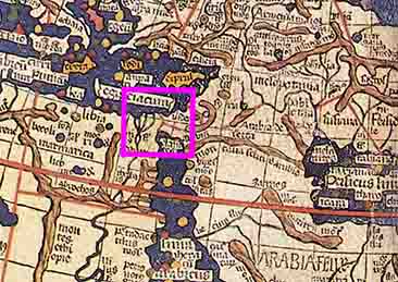
Perhaps it was because Greek focus centered on Egypt and the Mediterranean, that a hazy perception of Judea and Arabia persisted. But more likely, deliberate omission was a means of dispossession and disrepecting the sovereignty of smaller nations who resisted "hellenization". In modern times we find the practice of plotting large regions under one name in geographical maps delineating large continents as Asia, Europe, America, etc. --- however, the borders of established countries whose sovereignty is recognized on the world stage are nevertheless outlined within these larger regions. Yet within and overlapping these boundaries are national and tribal groups unrecognized and ignored in world politics unless perceived as rebels, freedom fighter or such. Furthermore, the bluring of boundaries between Arabia and Egypt may have its roots in an anachronism of earlier times, for according to Oahspe, in ancient times the area of Northern Africa also known as Ham [Khem] was considered to be the southern part of Arabia and was called "South Arabin'ya" this area included what later became Egypt.
No doubt centuries of earlier influences set the scene for Constantine's interpretation too. For, while Hellenic practices threatening traditional Judaism were successfully resisted by the Maccabees in Judea, Hellenic influence was widespread throughout the region during the rise of early Christianity. On the one hand the Tanakh (Ezra Bible) being translated into Greek (beginning in the 3rd century BCE and completed by 132 BCE) made it available to many gentiles as well as Alexandrian Jews; and in various areas of the Roman Empire it was common for gentiles to observe the Sabbath and Jewish holidays without giving up other non-Jewish religious beliefs and practices. On the other hand, Platonic and Egyptian Gnosticism influenced the forms of early Christianity. These blends of various world-views no doubt set the tone that would interpret the Old Testament in the context of Constantine's Christian New Testament. Subsequent history shows that all western maps up to 1750 CE continued to omit the Gulf of Eilat / Aqaba.
View Examples of Various Ancient Maps
Sebastian Munster's map (1545), Mercator (1584), John Speed (1626), Blaeu (1629), La Rue (1651), Visscher (1660), Moxon (1671), Wells (1700), and Vaugondy (1743). In none of these maps does the Gulf of Aqaba appear, yet the topography of the surrounding area including the area where the Gulf should appear ARE mapped out. AFAIK the earliest map to actually show the Gulf of Aqaba is the one by William Albert Bachine (1750).
Yam Suph
Having noted that the eastern arm of the Red Sea was ignored for many centuries, we trace back to its original name from the Hebrew scripts. The Red Sea was translated from the Hebrew Yam Suph and traditionally denoted the southern corner border of ancient Israel. Here was the Gulf of Eilat and to the north was the region of Petra:
Yam Suph is a [Hebrew] phrase which occurs about 23 times in the Tanakh (Hebrew Bible / Old Testament) and has traditionally been understood to refer to the salt water inlet located between Africa and the Arabian Peninsula, known in English as the Red Sea. (Wikipedia)
Numerous passages in the Ezra Bible indicate that Yam Suph refers to the Gulf of Eilat / Aqaba:
Where is Yam Suph (The Red Sea):
|| ...the [following] Hebrew text calls the Gulf of Aqaba "Yam Suph". This connects the phrase Yam Suph to a well-defined geographical location.
1 Kings 9:26: King Solomon built a fleet of ships at Ezion-geber, which is near Eloth on the shore of the Red Sea [Hebrew Yam Suph], in the land of Edom. (NRSV, comment added) Consider this: Solomon built that fleet of ships built for the purpose of trade, for sailing on the Red Sea, and not on some small Egyptian "reed sea".
The above-quoted 1 Kings 9:26 mentions Edom, Ezion-Geber and Eloth. The latter two were located at the northern end of the Gulf of Aqaba. The land of Edom began at the northern end of that gulf and stretched itself all the way to the Dead Sea. (Edom was located east of the line between those two seas)....In short: When the Bible connects the name Yam Suph to a clearly defined geographical location (1 Kings 9:26), it points to the Gulf of Aqaba which was and is a part of the Red Sea.||
More recently some scholars consider Yam Suph to refer to a "Reed Sea", which describes a shallow area of water where reeds grow. In ancient times these were the Bitter Lakes north of the Suez Gulf, the western arm of the Red Sea. This interpretation of Yam Suph has become popular lately partly because it remains within the Suez gulf region, the traditional Christian location of the crossing, but more significantly, it bolsters the arguments of such as seek to explain the miracles of the Exodus within the bounds of natural phenomena. Such attempts to explain the miracles, the Red Sea Crossing, and the events leading up to the Exodus require a selective imagination wherein events are skewed to fit geological phenomena such as earthquakes, volcanic eruptions, tsunamis, droughts, etc., while ignoring many details of recorded testimony.
While arguments for and against crossing-sites-depending-upon-depth-of-water may make sense to what humans believe is possible, the crossing through the depths of Yam Suph was a handed down tradition of the Israelites. The might of EOIh was demonstrated and remembered by the Israelites in the story of the Exodus and the Red Sea Crossing. The song of Miriam records the great event:
Oahspe; Book of the Arc Bon; 27/19.1-16.
Eloih, Almighty, You, my God, Who have delivered my people! I will sing to You a song; and the children of Israel to You, O Eloih!
You are a great strength and salvation; for You, Eloih, I will build my habitation; You, my father's God, O Eloih!
You are my Warrior; Eloih is Your name, forever!
You have encompassed Pharaoh and his hosts; they are swallowed up in the sea; his chosen captains and his warriors in the Red Sea.
The depths covered them up; they sank to the bottom like a stone, O Eloih!
Almighty Eloih; Glorious in power in Your right hand that passed over innocent blood!
You my God, Eloih; Wise in majesty, in Your right hand that dashed in pieces Your enemy!
Excellency, You O Eloih; Who in graciousness came upon those who rose up to block Your way; You sent Your breath upon them; as stubble they were cut down by Your righteous sword!
By the breath of Your nostrils, You heaped up the waters of the sea; and the floods stood upright by Your voice, to entrap them in the heart of the sea!
Your enemy said: I will pursue; I will overtake them; the spoil shall be mine; I will draw the sword; my hand shall destroy them!
You blew with Your wind; the sea covered them; they sank like lead in the mighty waters.
Who is like You, Eloih, among the Gods? Who is like You, Glorious in Holiness, fearful in praise and wonders, O Eloih! You stretc.hed out Your right hand, and they went down into the earth.
Merciful Almighty, Eloih, my God, and God of my fathers; Who has led forth Israel and delivered her into the land of her fathers, O Eloih! Who has guided them to a holy and peaceful habitation.
All people shall hear and be afraid; sober thought shall take hold on the inhabitants of Palestina. And the nobles of Edom shall be amazed! Trembling shall take hold of the warrior of Moab; and the wild men of Kana'yan shall melt away!
You, O Eloih, shall strike them with fear; by the magnitude of the strength of Your arm they will be amazed and helpless as stone. For this land is Your purchase, O Eloih; in the passover of the blood of the lamb You purchased it; and Israel shall pass over it in fear.
And You shall bring them to the mountain of their inheritance, to Your place, Our God, Eloih. To dwell in Your sanctuary, which You have established for Your reign, forever and forever.
Here in Moses and Miriam's song is the method by which the waters were made to part and remain parted while the Israelites crossed. The Ezra Bible differs only in phrasing rather than meaning "By the blast of your nostrils the waters piled up. The surging waters stood up like a wall; the deep waters congealed in the heart of the sea." One construct of this verse by Jonathan Gray is that the tunneled wind turned the water to ice, then when the wind abated so the Israelites could cross, the water remained at bay by the solid ice, which melted once the Israelites made it to the opposite shore and when the Egyptian army had almost completely entered the water.
From the words of this song, we also see that the events that occurred in Egypt were a lesson and a warning to those who would molest the non-resistant Israelites. It confirms that the Israelites did not wage a war for territory when they reached Canaan, but were left unmolested to live in their tents --- lest the mighty Israelite God pay their enemies in the same kind as Egypt. It was not until nearly four hundred years later, after many Israelites intermarried with the Canaanites, that their offspring and apostates began to imitate neighboring nations with kings and armies and consequently began to suffer at the hands of those same nations.
The Route to the Red Sea Crossing
Modern satellite images reveal the route of ancient dried up rivers and ancient
roads undetectable on the ground, the following account claims that such
evidence was discovered regarding the Exodus path:
Evidence of Exodus Path found by Nasa written by Don Kopp
|| November 1990, America shifts its Keyhole-satellite into
position over the Iraqi desert. The 55-feet-long, 12-ton spy satellite takes
pictures of the cold desert floor during the twilight hours. "Big
Bird," as the ground crews call it, has infrared scanners capable of
detecting a temperature difference of only 1/2 degree from its lofty perch of
155 miles.
Originally designed to detect underground missile silos (a silo's temperature
is slightly warmer than the surrounding earth), it was placed into position to
take pictures of the buried tanks. The tanks would heat up during the hot
daylight hours and continue to hold heat long after the rest of the desert
cooled during the night. The buried tanks showed up on the satellite photo like
neon signs. The exact location of each tank was then plotted on a target map
and given to American and British pilots who systematically eliminated them.
However, Big Bird photographed more than buried tanks. To everyone's amazement,
a thin red line (heated areas show up as red on infrared photos) coming from
the ancient site of Rameses in the Land of Goshen (Egypt), ran eastward,
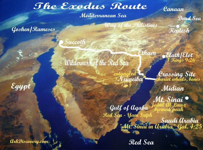
skirting the East Side of the Red Sea. "So God led the people around the
desert road toward the Red Sea" (Exodus 13:18).
The line went first to Succoth, lying just northeast of Rameses.... The line
then extended onward to Etham, and then over the high plateau of the Sinai Peninsula,
finally dropping down onto what is today called The Gulf of Aquaba, the
easternmost finger of the Red Sea.
One need only look at a map of this area to realize that the children of Israel
were now trapped. In front of them was the Red Sea Coming from behind them to
the northwest was Pharaoh's army. But, the thin red line emerged from the east
side of the Red Sea and continued onward, eventually ending up in present day
Saudi Arabia at the foot of a 3,465 foot mountain known as "Jabal al Lawz"
(Mountain of God) --- the real Mount Sinai!...||
Based on aerial observations and seafloor depths, two locations on the Gulf of Aqaba / Eilat have been identified. The first is Nuweiba, its full name in Arabic being Nuweiba El Muzema. One translation of its Arabic name is the "springing / bubbling water of Moses" or the "opening waters of Moses". The second site was proposed after Nuweiba, it is further south at the mouth of the Gulf at the Straits of Tiran. As we shall see, the evidence points unequivocably to Nuweiba as the most likely crossing site.
The significant features of the Nuweiba location led to its discovery by American, Ron Wyatt while flying over the area in an airplane in 1978. The distance between the two shores is from 8 to 11 miles and Wyatt and a number of others who have investigated the location claim that seafloor depths are significantly shallower than most nautical maps indicate. Depths from various sources range from 314, 317, 500, 765 and 780 feet at its deepest.
|
|
|
|
|
Sea-floor depths indicate a rare natural landbridge extending all the way from Nuweiba Beach in Egypt to the opposite shore in Saudi Arabia. Nautical maps of the gulf between Nuweiba El Muzeima (Muzeima translates as: Water of Moses) on the Egyptian shore and Saudi Arabia on the eastern bank. The maximum depth on the "landbridge" is shown as 765m. |
||
|
Above: Nuweiba in the Gulf of Aqaba, as a distinctly possible site for the Red Sea Crossing, was discovered accidentally from an airplane view |
||
|
Depth chart below indicates a more gradual drop off shore at Nuweiba at the "landbridge" and a depth of around 700 ft in the middle. |
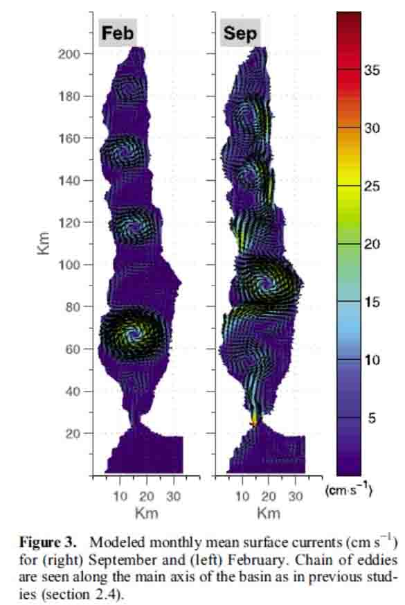
Circulation Chart below indicates consistent eddies on both sides of the Nuweiba "landbridge" associated with slow currents which explains why debris and wreckage remain in place long enough to be anchored by coral growth. |
|
|
|
|
|
|
The two images above appear courtesy of "The general circulation of the Gulf of Aqaba (Gulf of Eilat) revisited: The interplay between the exchange flow through the Straits of Tiran and surface fluxes" by E. Biton and H. Gildor; published 23 August 2011.
|
|
|

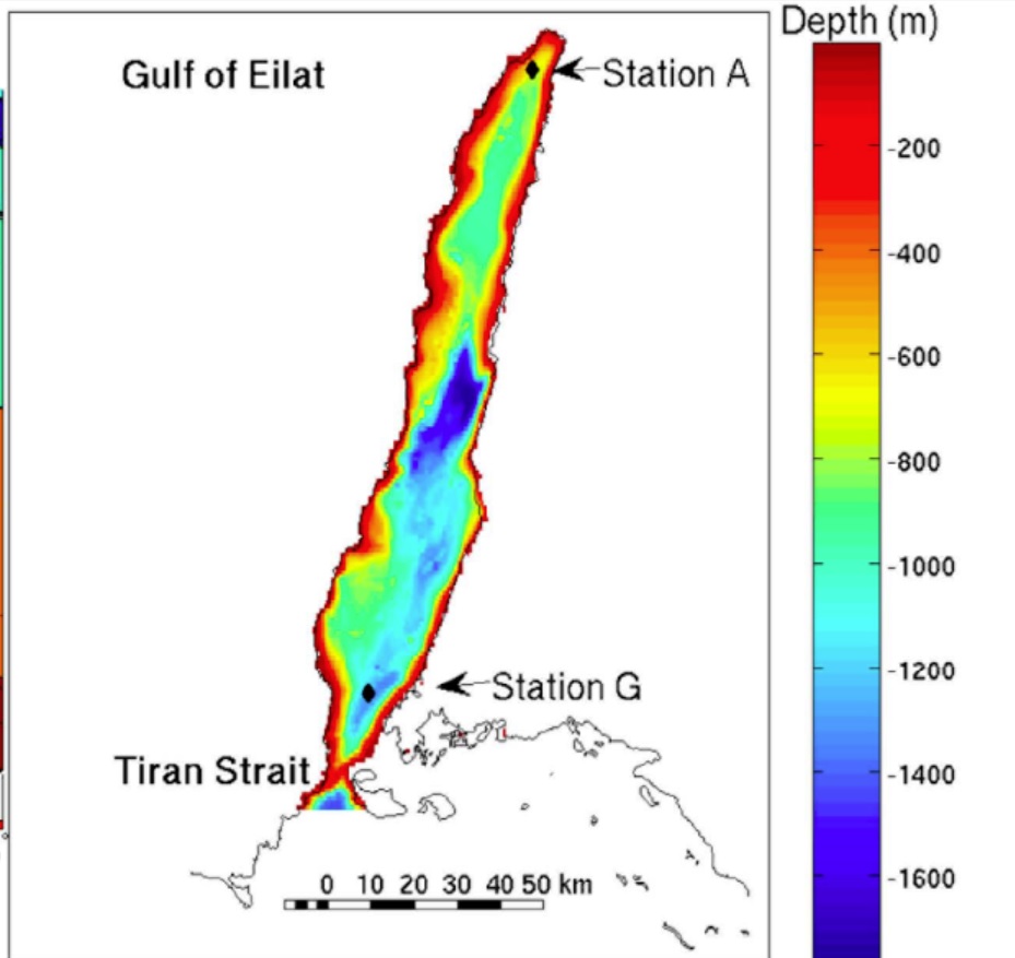
|| Today, using Bathymetric Maps and Three Dimensional Topographical Modeling on the Gulf of Aqaba's Sea Floor, from these maps, we can see the Gulf reaches phenomenal depths of over 5,7OO feet or more and that around 45 Miles South South West of Elat, at a place called Nuweiba on the Sinai Peninsula, there exists a land bridge 317 to 347 feet deep underwater and that this land bridge connects Nuweiba in Egypt, to the Saudi Arabian coast, 8 Miles to it's East.||
Wyatt's investigations at Nuweiba in 1978 revealed an ancient fallen column on the Egyptian shore, and on the Saudi Arabia side, Wyatt reported he found an identical column lying partly submerged in the water inscribed with ancient script. Underwater, scattered across the seafloor along the width of the landbridge are remains of chariots including wheels and axles, human and horse skeletal remains preserved by coral encrustations. The chariot wheel remains had four, six and eight spokes. Such wheels were confirmed by Egyptian antiquities experts to date back to the time of Ahmose I. But it is also known that chariots were already in Egypt some 200 years before, having been introduced by Asiatics during the Middle Kingdom.
Chariot Wheels found in the Red Sea
(Gulf of Aqaba)
|
|
|
|
|
|
The beach, extending into the sea forming a natural undersea land-bridge, is the result of millennia of erosion of desert sand and silt washing through mountain passes and wadis into the sea on both sides of the gulf. This is where chariot remains, as well as human and horse bone fragments, all preserved by coral encrustations, were found. It is the only place where such a crossing of the deep channels of the gulf would have been possible. While proponents for the Straits of Tiran at the Southernmost point of the gulf as being the crossing site claim it offers a slightly shallower depth (700 feet opposed to 765 feet at Nuweiba) the slope at Nuweiba is far more gradual, with an average grade of 6 degrees (wheelchair access grades are no higher than 4.8) the steepest at one point being 14 degrees.
There IS a Land Bridge off Nuweiba
|| There have been some "controversies" about the depth of the underwater landbridge that extends across the Gulf of Aqaba from the beach at Nuweiba -- and in May of 2000 a group from Australia and New Zealand went to the site and did extensive testing using Simrad CE32 Chart Plotter plus GPS to carry out depth soundings. It seems that the British Admiralty maps are inaccurate and unreliable -- our new tests matched the results of the Israeli Marine Geology Mapping & Tectonics Division...The Israelis report, "There IS a land bridge off Nuweiba" -- but we must remember that the Exodus happened over 3,400 years ago, and the underwater landbridge will have eroded and deteriorated over the years.....||
retrieved 18 Mar, 08.
|| March 27, 2005. We discovered that there is indeed an extremely gradual slope out to sea of about 1 in 14 as it goes out from Nuweiba, and about 1 in 10 as it rises back up to Saudi Arabia. Ian commented on how smooth the pathway was as well. Usually a seabed would be quite undulating, but we could see from the screen how easy it would have been for the Israelites to cross on such a smooth pathway. After returning from Egypt and evaluating information his company collected there, Jerry Harned said, "I have plotted a route across the Gulf of Aquaba from the Nuweiba side to the Saudi Arabian side that allows for an 8% grade. He said that his plot is based upon a recent depth chart published by Dr. John Hall of the Israeli Geological Survey." He admits that his calculation method may be primitive and that the results need expert review, but they are encouraging.
Our results also made sense, in light of this comment from the Israeli Marine Geophysicist and Head of the GSI's Marine Geology, Mapping & Tectonics Division. "In answer to your message to me via Ya'akov Arkin, there is a land bridge off Nuweiba. It rises to depths of slightly more than 850 m, with depths of greater than a kilometer to the north and south." That made sense, as the ETOP05 satellite map and the British Admiralty Chart have since been declared inaccurate.
Talking about the same formation other experts don't call it a land bridge. For example the Marine Geophysicist, & Head of the M.G., M. & T. Division said bluntly, "Your land bridge simply doesn't exist." However, he doesn't deny that the formation exists. Apparently the argument is, "does a 1/2 mile deep ridge constitute a land-bridge?" Either way, there's no doubt anymore that there is a smooth pathway across the Gulf of Aqaba at this place with a very steep drop off on either side....||
|
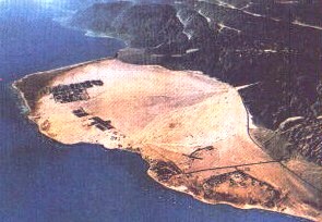
Satellite photograph of the Gulf of Aqaba |
Nuweiba on the Egyptian side of the Red Sea. |
|
|
|
|
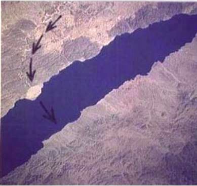
Left: The Red Sea Crossing site is located in the Gulf of Aqaba. There is only one place along the west coast of the Gulf of Aqaba that is big enough to hold 1-2 million people, and that is the beach at Nuweiba which is large enough to clearly be seen from space. |
Right: When Ron Wyatt went scuba diving at this location, he located a natural underwater land-bridge that crossed the gulf. He also found chariot wheels as well as human and horse bones preserved by coral encrustations. Since then other investigators have confirmed these findings and more. |
Whether or not the discoveries at Nuweiba are ever fairly investigated by the dominant paradigm and sentiment holders who tend to ignore history that includes phenomenon caused by a supernatural force, evidence offered by a number of investigators and researchers has been independently documented and published. While among other things, there are international political and cultural agendas that conspire to keep a lid on discoveries that confirm historical events contrary to popular and traditional viewpoints, the search for truth continues down the generations.
Decoding the Exodus of Moses according to the Ezra Bible with Oahspe
Oahspe's route taken by the Israelites essentially concurs with the Ezra Bible account. According to Oahspe, the details of the Ezra Bible account were gathered by Ezra and his scribes from the Egyptian records which existed in 496 bce.
Oahspe, Book of the Arc of Bon; 27/20.21; 18.2, 29.3;
||...Nevertheless.....[the records of the Exodus] were all written, in the first place not by the Israelites, but by their enemies, where, even so, the testimony of the miracles is none the weaker.
...After [Sukkoth] the Israelites passed through Etham, on the borders of the wilderness, and then on toward Migdol, near Baal‑zephon, the place of the oracle of the God, Baal, and they encamped before Pi'hahiroth, where Moses commanded them to remain some days to rest.
....Now from the place Sukkoth to [when they reached] the other side of the sea, a pillar of cloud preceded the Israelites by day, and a pillar of fire stood over them by night, and the people looked and everyone saw the cloud and the light. And the name of the place they reached when they crossed over was Shakelmarath; and they camped there many days.||
While the crossing, route and locations essentially match, many significant details of the Exodus story differ. These differences often indicate the source of the Ezra bible version as Egyptian, painted to make Moses appear conniving and deceitful. For instance the Ezra bible version has Moses seeking permission from Pharaoh to take more than 3 million people out into the desert on a pretext to do sacrifice for 3 days. But according to Oahspe, Moses' speech with Pharaoh was forthright and direct from the beginning:
Oahspe, Book of the Arc of Bon; 27/17.10.
Then Moses went before Pharaoh, taking Aaron with him. The king asked: What is your will? And Moses said: I have come to beseech you to allow my people to depart out of Egupt. The king replied: The Lord is with me; he says you shall not go; and I repeat the words of my God.
Then the Egyptian version claims that following the Passover, the Pharaoh had a change of heart and gave the Israelites permission to sacrifice in the wilderness for 3 days, and as the Israelites were being "driven out" they plundered the Egyptians of gold, silver and more (this story contradicts itself because if the Israelites were just going for 3 days, why would the Egyptians tolerate them demanding valuables and still allow them to go do their "sacrifice", and what for would they take the valuables if they were supposed to soon return?). Still following the Egyptian version, we find Pharaoh and the Egyptians have another change of heart again and want their slaves back again and presumably after 3 days expire, giving a head start to the Hebrews, Pharaoh musters his army and chariots for pursuit.
Oahspe, however, makes it clear that Pharaoh, consistently hard-headed and self-confident, had no changes of heart. Rather, the morning following the passover, finding his first born son and heir dead and the Israelites started out to freedom, he vows to destroy them utterly and thus sends his army in pursuit:
Oahspe, Book of the Arc of Bon; 27/18.16-18.
||...and the first‑born of the Eguptians fell dead, both man and beast. And Pharaoh's son died, and his brother's son; and the first‑born of every courtier, and every noble's first‑born, and all other people, their first‑born, so that in every family there lay one dead.
Pharaoh was now stricken, but not to repentance, for evil was in his heart, and he cursed Moses and the Israelites, and swore an oath to destroy Israel, man, woman and child, so that never again would there be one on the earth. And he sent his officers such a commandment, and to mobilize and begin the slaughter.
As for the Faithists, not many of them had slept during the night, but were providing for the journey, so that when morning came, every one of them started forth with the sunrise. From all the different regions of Egupt they went forth toward Sukkoth....||
Oahspe indicates the reason Pharaoh could not catch up to the Israelites until they reached the Red Sea, was because the angels of Jehovih kept Pharaoh's army in confusion allowing the Israelites sufficient time to make their way across the desert, following the spirit-cloud by day and spirit-fire by night, to the fore-ordained place where they would cross the Red Sea.
As has been previous demonstrated in earlier parts of this series, Egyptian versions of history were always retold to make Egyptian hegemony appear powerful and supreme. Various details throughout the Egyptian version / Ezra bible Exodus story falsely depict Moses as a traitor, killer, fugitive, spy and conniving deceiver, yet it still contradicts itself to say the Egyptians were well disposed toward him enough to happily hand over their valuables under supposed pressure from the Hebrews. Here we have an explanation that is closer to the actual events:
Oahspe, Book of the Arc of Bon; 27/18.19 -21.
||.....things had changed wonderfully with the Eguptians, for when they saw the Israelites were indeed going, and knew the miracles that had taken place, they relented, and brought them gifts of gold and silver; and also asses and camels for the Hebrew women and children to ride upon; and gave them food to eat. But the Israelitish women said: No, if we take these things we will be under obligations to the Eguptians. The Israelites do not accept what they cannot pay for. Then the Eguptians bewailed in fear, saying: So that we will not be accursed by the Gods, take them, we beseech you in the name of your God also.
So the Faithist women accepted the presents of asses, camels, and other things besides; and they mounted the asses and camels, and rode them.
When Moses heard of this afterward he rebuked Israel, saying: Because you have accepted these things it will be said, you borrowed and begged them so as to despoil the Eguptians.||
A face saving device for Pharaoh and his army is also devised by a feigned explanation of how the Israelites got to the other side of the wilderness before the Egyptians managed to catch up. Rather than admit a confused army in disarray unable to find 4 million people in the desert for several weeks (which was another miracle of the Exodus), the Egyptian version would have it that a 3 day head-start ahead of a mobile army of chariots and horses, allowed them to keep ahead of the Egyptian Army for nigh on 25-30 days till they reached and encamped by the Red Sea. Is it any wonder then that many bible scholars find it hard to believe the Red Sea crossing took place on the far side of the wilderness through the mighty waters of the Yam Suph?
Furthermore, the Hyksos Expulsion of 1550 BCE is nothing more than an Egyptian version of the Exodus, with a "double rinse and bleach" to make the Pharaoh of the Exodus, Ahmose I appear victorious and heroic chasing a bunch of Asiatic invaders out of Egypt.
According to Oahspe (and given the multitudes of people, with children, animals, carts, tents, food, etc.) a more realistic description of the trek is revealed. For instance Moses stayed for 12 days at Sukkoth while the multitude marched past him on the way to Etham [Modern Day El Thammed], and then south toward the shore of the Red Sea. Considering that Sukkoth was only a relatively short distance from Egypt's residential hub in the delta, it is indeed a miracle that the army did not discover them there or anytime before they reached the shores of the eastern gulf of the Red Sea.
Oahspe, Book of the Arc of Bon; 27/18.18, 22 - 31,
||....From all the different regions of Egupt they went forth toward Sukkoth [Succoth]... The Heads led the way, and every commune was led by a rab'bah, and every man's family by the father of the family or by the eldest son.
When they arrived near Sukkoth, Jehovih spoke to Moses and Aaron, saying: Stand here for twelve days, so that you may see My people as they pass, and that you in turn may be seen by them. So Moses and Aaron pitched their tents on a high piece of ground off to the side, and remained there twelve days, and Moses showed himself before them, speaking and encouraging.
After this the Israelites passed through Etham, on the borders of the wilderness, and then on toward Migdol, near Baal‑zephon, the place of the oracle of the God, Baal, and they encamped before Pi'hahiroth, where Moses commanded them to remain some days to rest.
Now as for Pharaoh, he had not made any attack on the Israelites, for Jehovih's Lord held his army in confusion. Pharaoh, finding that the Israelites were not injured, decided to take to the field himself; and accordingly, having impressed all the chariots of Egupt, went ahead, leading his army in person. The Israelites were wearied and footsore, and, discovering that Pharaoh was after them, many of them complained and grumbled, saying: O Moses, why did you bring us from home? It would have been better for us to remain in servitude to the Eguptians than to be slain.
Moses rebuked them, saying: You profess to be Faithists but yet have no faith in Jehovih? Put your trust in Him; for He will deliver you safely, as He has promised.
Jehovih spoke to Moses, saying: They shall witness the salvation of My hand; for the Eguptians who pursue them this day shall never again pursue them. For when you lead them to the sea, you shall lift up your rod, and I will divide the sea, and My people shall walk across on the land of the bottom of the sea. And Pharaoh's army shall pursue, but be swallowed up in the waters. And so it came to pass:
Jehovih brought a strong wind and divided the waters of the sea and swept them back, and the Israelites went over on land. But Pharaoh's army, who were in pursuit, were caught in the flood of the tide and were drowned.
Thus Jehovih delivered the Israelites out of Egupt; and Israel believed in Him and in Moses, His servant.
Now from the place Sukkoth to the other side of the sea, a pillar of cloud preceded the Israelites by day, and a pillar of fire stood over them by night, and the people looked and everyone saw the cloud and the light. And the name of the place they reached when they crossed over was Shakelmarath; and they camped there many days.
From the time Moses began to prepare for the migration of Israel until he reached Shakelmarath, was four years two hundred and seven days. And the number of Israelites who went forth out of Egupt was three million seven hundred and fifty thousand, men, women and children. And the number of other people who accompanied them was four hundred thousand; and because they were of the uncircumcised tribes of ancients, the Hebrews nicknamed them Levites, i.e., imperfect flesh. [This means a total of 4,150,000 people walked out of Egypt and crossed the Red Sea]
And Moses commanded the Levites to camp aside, and not to mix with the Israelites, and they obeyed him in all things, maintaining that they were the true descendants of Abraham....||
All Oahspe references are from the Standard Edition Oahspe of 2007
● GO TO NEXT ARTICLE:
Universal Family